
Sugarloaf Dam
| Sugarloaf Dam | |
|---|---|
 Aerial view of the reservoir, 2017 | |
 Sugarloaf Dam Location of the dam in Victoria | |
 Interactive map of Sugarloaf Dam | |
| Country | Australia |
| Location | Christmas Hills (near Yarra Glen), Victoria |
| Coordinates | 37°40′28″S 145°17′31″E / 37.67431°S 145.291936°E |
| Purpose | Water supply |
| Status | Operational |
| Opening date | 1981 |
| Built by | Thiess Brothers |
| Designed by | Melbourne & Metropolitan Board of Works |
| Operator | Melbourne Water |
| Dam and spillways | |
| Type of dam | |
| Impounds | Sugarloaf Creek |
| Height (foundation) | 89 m (292 ft) |
| Length | 1,050 m (3,440 ft) |
| Dam volume | 4,700×103 m3 (170×106 cu ft) |
| Spillways | 1 |
| Spillway type | Uncontrolled |
| Spillway capacity | 11 m3/s (390 cu ft/s) |
| Reservoir | |
| Creates | Sugarloaf Reservoir |
| Total capacity | 99,220 ML (80,440 acre⋅ft) |
| Active capacity | 96,253 ML (78,034 acre⋅ft) |
| Catchment area | 9.15 km2 (3.53 sq mi) |
| Surface area | 445 ha (1,100 acres) |
| Normal elevation | 173 m (568 ft) AHD |
| Sugarloaf Hydroelectric Power Station | |
| Commission date | 20 March 1929 |
| Decommission date | c. 2010 |
| Type | Mini-hydro |
| Installed capacity | 4 MW (5,400 hp) |
| Website melbournewater.com.au | |
| [1] | |
The Sugarloaf Dam is a rock-filled embankment dam, with saddle embankments, across the Sugarloaf Creek and a minor tributary, located near Christmas Hills, 35 kilometres (22 mi) north-east of the Melbourne central business district, in Victoria, Australia. Completed in 1981, the resultant eponymous reservoir, the Sugarloaf Reservoir, was established for the supply of potable water to Greater Metropolitan Melbourne. A mini-hydro power station was located at the site, however, it was subsequently decommisioned.
The dam and reservoir are operated by Melbourne Water.[2]
Dam and reservoir overview
[edit]Dam
[edit]The dam was completed by Thiess Brothers in 1981.[3] The rock-filled dam wall is 90 metres (300 ft) high and 1,000 metres (3,300 ft) long. When full, the resultant reservoir has a storage capacity of 99,220 megalitres (80,440 acre⋅ft) and covers 445 hectares (1,100 acres), drawn from a catchment area of 9.15 square kilometres (3.53 sq mi). The uncontrolledspillway has a discharge capacity of 11 cubic metres per second (390 cu ft/s). The adjacent rock-filled saddle dam wall is 17 metres (56 ft) high and 528 metres (1,732 ft) long.[1]
Facilities at the complex include a major pumping station and water treatment plant. Water pumped from the Yarra River at Yering Gorge and water transferred from Maroondah Reservoir via the Maroondah aqueduct empty into the Sugarloaf Reservoir, that assist in meeting peak summer demand in the northern parts of Greater Melbourne. In February 2010, the North South Pipeline was completed, connecting the Goulburn River to the reservoir. It is the government's policy that water from the Goulburn only be used in times of critical human need: when Melbourne's total water storages are less than 30% full on 30 November of any year.[4]
Reservoir
[edit]Sailing
[edit]The Sugarloaf Sailing Club operates on the reservoir year round. The club can be found on Ridge Road off the Eltham-Yarra Glen Road. The club runs over 40 races throughout the year in four series, "Winter", "Spring", "Summer" and "Autumn". There is a strong racing fraternity at Sugarloaf who can be found on the lake on race days, rain, hail or shine. New members can use the boats from the club fleet without further charges. The club also conducts sailability on the first Wednesday of the month during the warmer months. Sailability is sailing for all including the young, the elderly and disabled, uses dinghies which are unsinkable, uncapsizable and good fun.
Fishing and walks
[edit]Sugarloaf Reservoir is also a very popular waterway for recreational fishing. Rainbow and brown trout, redfin, roach and European carp can be caught in these waters all year round. No natural bait or berley is permitted, there are signs posted around the reservoir stating this. This is due to the reservoir being an integral component of Melbourne's domestic water supply.[5] There have been studies conducted that suggest that the mercury levels in the redfin (and most likely other predatory fish in the reservoir) are higher than is regarded safe for human consumption.[6]
Hydroelectric power station
[edit]The Sugarloaf Hydroelectric Power Station is a decommissioned mini-hydro power station, opened 20 March 1929 by the Premier Sir William McPherson.[7] The capacity of the power station was 4 megawatts (5,400 hp) until it was decommissioned in c. 2010.[8]
Gallery
[edit]-
 The former Sugarloaf Power Station and dam at Sugarloaf Reservoir (same location as present-day Lake Eildon)
 -
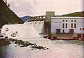
 Water levels at 80% capacity in April 2010


See also
[edit]References
[edit]- ^ a b "Register of Large Dams Australia-2015" (Excel. Requires download. Row 475-476). ANCOLD. January 2022. Retrieved 5 March 2026.
- ^ "Sugarloaf Reservoir". Melbourne Water. Retrieved 26 October 2008.
- ^ "Toyota Celebrates 60 Years of Helping Build Australia". Busch Taxi. 26 September 2019. Retrieved 3 January 2020.
- ^ "North–South Pipeline". Melbourne Water.
- ^ Sugarloaf Reservoir Park, Visitor Guide (PDF), Parks Victoria, August 2011, retrieved 29 October 2011
- ^ "DELWP". 10 November 2020.
- ^ "OPENING OF THE NEW HYDRO-ELECTRIC POWER STATION AT SUGARLOAF(V.) RESERVOIR ON MARCH 20". The Australasian. Vol. CXXVI, no. 4, 186. Victoria, Australia. 30 March 1929. p. 67 (METROPOLITAN EDITION). Retrieved 7 January 2019 – via National Library of Australia.
- ^ "Hydropower: Power stations". Melbourne Water. 24 November 2023. Retrieved 12 May 2026.
External links
[edit]![]() Media related to Sugarloaf Reservoir at Wikimedia Commons
Media related to Sugarloaf Reservoir at Wikimedia Commons
- "Sugarloaf Reservoir". Melbourne Water.
- Sugarloaf Pipeline South-North Transfer: Preliminary Business Case Summary (includes schematics). Department of Environment, Land, Water and Planning (Report). Victorian Government. 2016. pp. 5–6. ISBN 978-1-76047-354-9. Retrieved 12 May 2026.
 This article incorporates text from this source, which is by State of Victoria available under the CC BY 4.0 license.
Waterways of the Melbourne Water catchment, Victoria, Australia | |
|---|---|
| Rivers |
|
| Creeks |
|
| Lakes (natural) |
|
| Reservoirs | |
| Drains |
|
| Other | |
| |||||||||||||||||||
| |||||||||||||||||||
- 1981 establishments in Australia
- Concrete-face rock-fill dams
- Dams completed in 1981
- Dams in Victoria (state)
- Former power stations in Australia
- Hydroelectric power stations in Victoria (state)
- Melbourne Water catchment
- Reservoirs in Victoria (state)
- Rivers of Greater Melbourne (region)
- Yarra Ranges Shire
- Former hydroelectric power stations