
Meers, Oklahoma
Meers, Oklahoma | |
|---|---|
 Meers in March 2025 | |
 Meers Location within the state of Oklahoma  Meers Meers (the United States) | |
| Coordinates: 34°46′58″N 98°34′44″W / 34.78278°N 98.57889°W[1] | |
| Country | United States |
| State | Oklahoma |
| County | Comanche |
| Elevation | 1,460 ft (450 m) |
| Time zone | UTC-6 (Central (CST)) |
| • Summer (DST) | UTC-5 (CDT) |
| ZIP codes | 73558 |
| FIPS code | 40-47500 |
| GNIS feature ID | 1100624[1] |
Meers is an unincorporated community located on State Highway 115 in Comanche County, Oklahoma, United States, in the foothills of the Wichita Mountains. In 1901, Meers was founded as a gold prospecting town where it was named in honor of mine operator Andrew J. Meers from Cherokee County, Georgia.
The only remaining structure of the original town is the Meers Store & Restaurant, which Food Network named as the best hamburger joint in Oklahoma and one of the best in the United States, largely due to its signature MeersBurger.[2]
The Meers Store also served as the area post office from March 12, 1902, until February, 1989.[3] Currently, area residents have Lawton mailing addresses.
Geological formation of Southwest Oklahoma
[edit]
Meers is defined by a geological displacement or planar fracture known as the Meers Fault.[4] The northwestern Meers fault and the southeastern Meers fault lines are geologically situated in the central lowlands.[5][6]
In 1985, in order to monitor a seismic event, the Oklahoma Geological Survey installed a seismograph in the Meers Store.[7]
Listing as National Register of Historic Places
[edit]The Meers Store was listed on the National Register of Historic Places in 1978 as Meers Mining Camp, since it was the only surviving relic of the community's gold rush days.[8][9]
References
[edit]- ^ a b c U.S. Geological Survey Geographic Names Information System: Meers, Oklahoma
- ^ Food Network Top American Restaurants: Bon Appetit Picks the Best. Archived 2007-10-20 at the Wayback Machine
- ^ Shirk, George H. (1952). "First Post Offices Within the Boundaries of Oklahoma". The Chronicles of Oklahoma. 30 (1 - Spring 1952). Oklahoma Historical Society: 79, 38–104. LCCN 23027299. OCLC 655582328.
- ^ Luza, Kenneth V. "Earthquakes". The Encyclopedia of Oklahoma History and Culture. Oklahoma Historical Society.
- ^ "Northwestern Meers Fault". Northwestern Section (Class A) ~ Fault ID No. 1031a. U.S. Geological Survey.
- ^ "Southeastern Meers Fault". Southeastern Section (Class A) ~ Fault ID No. 1031b. U.S. Geological Survey.
- ^ Oklahoma Geological Survey Seismograph Stations Archived 2007-04-16 at the Wayback Machine. (accessed February 14, 2007)
- ^ "Meers Mining Camp ~ 78002230". National Register Digital Assets. National Park Service. January 20, 1978.
- ^ "NRHP nomination for Meers Mining Camp". National Park Service. U.S. Department of Interior. Retrieved November 3, 2017.
Depictions of Meers, Oklahoma
[edit]Meers Restaurant & Store Wind turbines of Blue Canyon Wind Farm near Meers, Oklahoma |


Bibliography
[edit]- Allen, Iva Williams (1954). "Early Days in Meers". The Chronicles of Oklahoma. 32 (3 - Autumn 1954). Oklahoma Historical Society: 278–289. LCCN 23027299. OCLC 655582328.
- Wilson, Steve (1976). Oklahoma Treasures and Treasure Tales. Norman, Oklahoma: University of Oklahoma Press. ISBN 978-0806121741. OCLC 1137911.
- Hale, Duane K. (1981). "Gold in Oklahoma: The Last Great Gold Excitement in the Trans-Mississippi West, 1889-1918". The Chronicles of Oklahoma. 59 (3 - Fall 1981). Oklahoma Historical Society: 304–319. LCCN 23027299. OCLC 655582328.
- Wilson, Steve (1982). Dauntless Gold Seekers of the Wichitas [Drill Bits, Picks, and Shovels: A History of Mineral Resources in Oklahoma]. The Gateway to Oklahoma History. Oklahoma City, Oklahoma: Oklahoma Historical Society. pp. 132–161. ISBN 0941498247. LCCN 82-81962. OCLC 982029050.
- Everett, Dianna. "European Exploration". The Encyclopedia of Oklahoma History and Culture. Oklahoma Historical Society.
- Weaver, Bobby D. "Gold". The Encyclopedia of Oklahoma History and Culture. Oklahoma Historical Society.
- Shirk, George H. (January 1, 1987). Oklahoma Place Names. Norman, Oklahoma: University of Oklahoma Press. ISBN 978-0806120287. OCLC 15805183.
- Jones, Peter D. (2021). "The First Coins of the Americas". Internet Archive. Bookbaby.
Historical Video Archive
[edit]| ☆ Back In Time: The Lost Gold of Oklahoma on YouTube |
| ☆ The Coronado Expedition : Coronado National Memorial on YouTube |
External links
[edit] Media related to Meers, Oklahoma at Wikimedia Commons
- "Arrastra Site ~ Wichita Mountains Wildlife Refuge" [National Register of Historic Places Inventory - Nomination Form for Federal Properties]. U.S. National Park Service. U.S. Department of the Interior. May 11, 1981.
- "Arrastra Site ~ Wichita Mountains Wildlife Refuge - NRIS No. 81000455". U.S. National Park Service. U.S. Department of the Interior. May 11, 1981.
- "Meers General Store". Jim Argo Collection ~ Gateway to Oklahoma History. Oklahoma Historical Society.
Municipalities and communities of Comanche County, Oklahoma, United States | ||
|---|---|---|
| Cities | 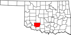 | |
| Towns | ||
| CDPs | ||
| Other communities | ||
| Footnotes | ‡This populated place also has portions in an adjacent county or counties | |
| International | |
|---|---|
| National | |
| Other | |