
Polur, Iran
Polur
Persian: پلور | |
|---|---|
Village | |
.jpg) The village of Polur and the Haraz Road, with Mount Damavand in the background | |
 Polur | |
| Coordinates: 35°50′55″N 52°03′01″E / 35.84861°N 52.05028°E[1] | |
| Country | Iran |
| Province | Mazandaran |
| County | Amol |
| District | Larijan |
| Rural District | Bala Larijan |
| Population (2016)[2] | |
• Total | 302 |
| Time zone | UTC+3:30 (IRST) |
Polur (Persian: پلور)[a] is a village on the Haraz River in Bala Larijan Rural District[4] of Larijan District in Amol County, Mazandaran province, Iran.
Demographics
[edit]Population
[edit]At the time of the 2006 National Census, the village's population was 316 in 86 households.[5] The following census in 2011 counted 210 people in 72 households.[6] The 2016 census measured the population of the village as 302 people in 151 households.[2]
Geography
[edit]The village is located on Road 77 (Haraz Road), the main route from Amol to the Caspian Sea coast. At the 2016 census, its population was 302, in 151 families.[7]
Mount Damavand—Alborz Mountains
[edit]It is well known for being a popular base to climb Mount Damavand in the Lar National Park, part of the Central Alborz mountain range. The 5,610 m (18,410 ft) volcano is the highest point in Iran and in the Middle East region.
| Map of central Alborz | Peaks: | 1 Alam-Kuh |
|---|---|---|
 −25 to 500 m (−82 to 1,640 ft) 500 to 1,500 m (1,600 to 4,900 ft) 1,500 to 2,500 m (4,900 to 8,200 ft) 2,500 to 3,500 m (8,200 to 11,500 ft) 3,500 to 4,500 m (11,500 to 14,800 ft) 4,500 to 5,610 m (14,760 to 18,410 ft) |
2 Azad Kuh | 3 Damavand |
| 4 Do Berar | 5 Do Khaharan | |
| 6 Ghal'eh Gardan | 7 Gorg | |
| 8 Kholeno | 9 Mehr Chal | |
| 10 Mishineh Marg | 11 Naz | |
| 12 Shah Alborz | 13 Sialan | |
| 14 Tochal | 15 Varavašt | |
| Rivers: | 0 | |
| 1 Alamut | 2 Chalus | |
| 3 Do Hezar | 4 Haraz | |
| 5 Jajrood | 6 Karaj | |
| 7 Kojoor | 8 Lar | |
| 9 Noor | 10 Sardab | |
| 11 Seh Hazar | 12 Shahrood | |
| Cities: | 1 Amol | |
| 2 Chalus | 3 Karaj | |
| Other: | D Dizin | |
| E Emamzadeh Hashem | K Kandovan Tunnel | |
| * Latyan Dam | ** Lar Dam |
Gallery
[edit]-
 Shahi Bridge crossing the Haraz River in Polur.
 -
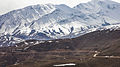 Alborz mountain range and Lar National Park from Polur.
 -
 Haraz River and Mount Damavand from Polur.
 -
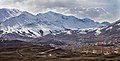 Haraz River Valley and Alborz range from Polur.
 -
 Zaman Valley, Mazandaran Province, Iran
 -
 Lar National Park
 -
 Shahi Bridge, Polour
 -
 Shahi Bridge, Polour
 -
 Shahi Bridge, Polour
 -
 Zaman Valley, Mazandaran Province, Iran
 -
 Zaman Valley, Mazandaran Province, Iran
 -
 Firoozeh Water Basin
 -
 Firoozeh Water Basin, Zaman Valley, Mazandaran Province, Iran
 -
 Firoozeh Water Basin, Zaman Valley, Mazandaran Province, Iran
 -
 Lar National Park
 -
 Zaman Valley, Mazandaran Province, Iran
 -
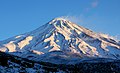 Mount Damavand
 -
 Mount Damavand
 -
 Mount Damavand


See also
[edit]![]() Media related to Polur, Iran at Wikimedia Commons
Media related to Polur, Iran at Wikimedia Commons
Notes
[edit]References
[edit]- ^ OpenStreetMap contributors (26 December 2025). "Dasht-e Maghdam, Polour, دهستان بالالاریجان, بخش لاریجان [Bala Larijan Rural District, Larijan District], Amol County, Mazandaran Province, Iran" (Map). OpenStreetMap (in Persian). Retrieved 26 December 2025.
- ^ a b سرشماري عمومي نفوس و مسكن 1395 : استان مازندران [General Population and Housing Census 2016: Mazandaran Province]. مرکز آمار ایران [Statistical Centre of Iran] (in Persian). Archived from the original (Excel) on 7 October 2021. Retrieved 19 December 2022.
- ^ Polur at GEOnet Names Server
- ^ Mousavi, Mir-Hossein (9 August 1987) [تاریخ تصویب (Approval date) 1366/05/18 (Iranian Jalali calendar)]. ایجاد و تشکیل تعداد 4 دهستان شامل روستاها، مزارع و مکانها در شهرستان تنکابن تابع استان مازندران [Creation and formation of 11 rural districts including villages, farms, places in Amol County under Mazandaran province]. مرکز پژوهشهای مجلس شورای اسلامی ایران [Research Center of the Islamic Consultative Assembly of Iran] (in Persian). وزارت کشور [Ministry of the Interior]. مجلس شورای اسلامی [Islamic Consultative Assembly]. پیشنهاد شماره [Proposal No.] 11698.1.5.53. Archived from the original on 26 September 2017. Retrieved 23 December 2025.
- ^ سرشماري عمومي نفوس و مسكن 1385 : استان مازندران [General Population and Housing Census 2006: Mazandaran Province]. مرکز آمار ایران [Statistical Centre of Iran] (in Persian). Archived from the original (Excel) on 20 September 2011. Retrieved 25 September 2022.
- ^ سرشماري عمومي نفوس و مسكن 1390 : استان مازندران [General Population and Housing Census 2011: Mazandaran Province]. Iran Data Portal—Syracuse University (in Persian). مرکز آمار ایران [Statistical Centre of Iran]. Archived from the original (Excel) on 19 January 2023. Retrieved 19 December 2022.
- ^ "Census of the Islamic Republic of Iran, 1395 (2016)" (Excel). Islamic Republic of Iran.
This Amol County location article is a stub. You can help Wikipedia by adding missing information. |